


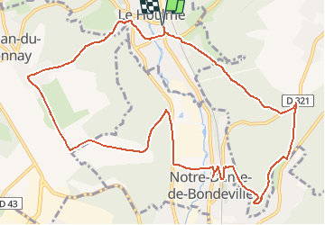
Le houlme

nathycandy
User

Length
12.4 km

Max alt
146 m

Uphill gradient
329 m
Km-Effort
16.8 km

Min alt
22 m

Downhill gradient
330 m
Boucle
Yes
Creation date :
2014-12-10 00:00:00.0
Updated on :
2014-12-10 00:00:00.0
3h35
Difficulty : Difficult

FREE GPS app for hiking
 SityTrail
IGN / Geographical institutes
SityTrail Plus
The world is yours!
About
Trail Walking of 12.4 km to be discovered at Normandy, Seine-Maritime, Le Houlme. This trail is proposed by nathycandy.


Positioning
Country:
France
Region :
Normandy
Department/Province :
Seine-Maritime
Municipality :
Le Houlme
Location:
Unknown
Start:(Dec)
Start:(UTM)
358080 ; 5485799 (31U) N.
Comments